Showing posts with label southside. Show all posts


For the past few weeks I’ve been pouring over the documents and press releases connected with the City plan to build a traffic circle -- aka a roundabout -- at the intersection of Richland Ave. and State Route 682. The entire Richland/682 proposal is a major one, with road improvements that will run from Dairy Lane, where a traffic light is set to be installed, to the intersection between the Convo and Peden Stadium. More than half of a 3 million Ohio Department of Transportation grant will go towards repairing the deck of the Richland Bridge, but it’s the roundabout that has generated the most discussion. Those interested can review 3D simulations of the two main intersection choices at http://www.ci.athens.oh.us/streets/richland.html

This post and my next one will take a look at the pros and cons of the roundabout proposal from a motorist and traffic safety perspective, then from a pedestrian angle, with something on funding thrown in for good measure.

Traffic safety has been the motivating force behind the project. A 2004 ODOT study ranked the Richland/682 intersection as the 78th most dangerous in the state. The problem is mainly that the intersection is not only heavily traveled but mixes high speed traffic on 682 with low-speed travelers on Richland. The tendency is for the 682 drivers to continue through the traffic signal, setting up the conditions for broadside collisions and pedestrian accidents. I admit to having spaced out and nearly run a red myself on one occasion coming down 682, and I consider myself at least a near-average driver, so the problem may be common.

After reading up on the options, I’m inclined to agree with Athens Streets Director Andy Stone: a roundabout looks like the most elegant long term solution.
There’s no way for us drivers to “run” a shrub-filled center median the way we can a traffic light, and hence the possibility of high-speed accidents should be greatly reduced. During normal traffic flow, drivers are able to get through a roundabout more rapidly than they would a traditional intersection, and at peak traffic times, such as sporting events, a police officer could direct traffic, since many are already in the area for security reasons.

The protest has been made that American drivers are unfamiliar with the concept of roundabouts and that having one at the intersection will cause confusion and an increase in fender benders. This may be true, but I give our drivers credit for more smarts than some may: with the proper signs posted most should learn quickly. The fact that negotiating a roundabout requires both hands on the wheel might even prompt a few clueless motorists to actually (gasp) put away their cell phones for once!

All of the above was written several days ago, but I just saw the aftermath of a tragic high-speed accident that underscores the need for something to be done about the intersection. As I was driving in on 682 yesterday I came upon two fire trucks and a sedan with its entire front end bashed in. An article in today’s Messenger lists both drivers as injured and say that police are seeking witnesses to the moment of the crash, since no one apparently stopped to investigate -- a sad testament to our self-absorbed state in these times. My thoughts, prayers and hopes for full recovery go out to the drivers and their families.

7.07.2008

Viewshed This!


Well, it looks like the horses are out the barn door on this one. Edwards Communities of Columbus has been very busy the past month, and they've successfully stripped the entire 32-acre site above Richland and Dairy Lane down to raw earth. Besides prepping for the massive apartment complex that the company plans to build there, the speed and completeness of the clearcut suggests a defensive move to counter any further roadblocks the mayor and city council may try to throw up in the way of the project. It would take something approaching a strip mine reclamation and a good 30-50 years to return the property to anything resembling mature woodland again. Disputes over Edwards' plan to blast the hillside are still playing out. Anyone with a taste for irony should savor the fact that Edwards plans to name a development that will lower the ridge 28-40 feet "The Summit at Coates Run".

I'll find time to write more about Edwards and their plans later, but for now I want to invite the south siders whose homes border the earthworks to participate in a sort of public memory project. If you have photos or stories of the Coates Run woods that you'd like to share, send them to athwatch at gmail.com, my blog email address, and I'll post them here (make sure to send descriptive captions with your photos). Having walked the ridge above Coates Run in earlier years, I'd like to see the beauty of that particular part of Athens remembered properly.

It’s that season again. Building season. The season of capital improvements. Summer. No students, no frost, no rain (at least by July), potentially meddlesome people off on vacation, so bust out the heavy machinery! And where better to start the summer than Athens’ own South Side?

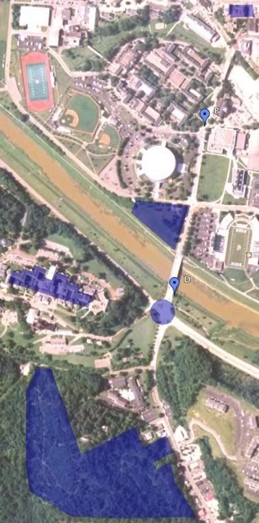
The corridor along Richland Avenue has been in local news regularly, both as a hotspot for City, University and private development and as the location of two high-profile traffic accidents which have prompted intense debate over the adequacy of the current infrastructure. Since keeping up with all of the plans and issues is a real chore, The Attention-Getting Device presents a handy cheat sheet and visual reference, progressing from North to South along Richland Ave:


View Larger Map

The map appears courtesy of Google. Use the +/- buttons to zoom in and click on any blue area to read a more detailed description. If the map refuses to load in your browser, you can view it directly on the Google Maps site, or, if all else fails, download a jpeg picture version here.

A. Removal of Haning Hall at the intersection of Union and Richland and widening of the north end of Richland to a 2-way street. (OU, City of Athens, in discussion, no start date announced yet.)

B. Safety Issue: Pedestrian crossing between Grover and Porter Halls where an OU grad student sustained a serious head injury when he was hit by a truck in September of 2004. (OU, CoA, no solid plan for change.)

C. Construction of proposed new student health center on site of current tailgating field and welcome center across Richland from Peden Stadium. (OU, in discussion, no start date announced yet.)

D. Safety Issue: Richland Bridge site of a June 2007 accident where an OU graduate student was struck and killed by a drunk driver who allegedly ran a red light at the Richland/S.R.682 intersection. (CoA, see project below).

E. Widening of Richland Avenue Bridge to protect sidewalks and construction of proposed Richland/682 roundabout. (CoA, in site review and planning stage.)

F. Renovation or demolition of large sections of the Ridges complex. (OU, in discussion, no planned date.)

G. Construction of The Summit at Coates Run, an 870-bed student apartment complex, south of Dairy Lane behind the OU Inn. (Edwards Development, Columbus, in progress.)