In the past four years, the loudest complaint about the OU/NCR retirement development has been that it would occupy valuable green space currently used by the entire community. This is no idle concern. The Near East Side is one of Athens’ densest neighborhoods and has no park space apart from the river acreage that NCR would be building on (and no, a 1-acre elementary school playground cannot serve the needs of the entire neighborhood). Despite the fact that it has never been intentionally developed as parkland, the current space is far from vacant - it is a place where Athenians go to walk their dogs, play soccer, baseball, golf and frisbee, fly kites, or just sit in the sun.
Perhaps most importantly, the open frontage on the river provides a kind of intangible release valve for the feeling of being hemmed in and urbanized. Many east-siders already express feelings of uneasiness about the encroachment of the crowded, dirty and loud student neighborhoods to the south of Stimson, and up till now the strip of land along the river has provided a haven of peace and quiet. While the NCR development won’t doom the East Side by itself, it all but kills one of its major selling points, and if OU loses the East Side as a viable family neighborhood, it has lost pretty much the only faculty/staff/grad student housing currently within walking or cycling distance of the campus -- and you thought not having attractive in-town retirement options was hurting faculty recruitment!
When the plans were originally unveiled, OU justified the loss of parkland by suggesting that they would replace it with comparable space on the site of Mill Street Apartments, which at the time were scheduled for demolition.1 That site, which is situated directly across Stimson Ave. from the proposed retirement community, was eventually renovated instead. Another suggestion - that land across the river be substituted as recreation space - would require the Stimson Ave. bridge to be upgraded to handle pedestrians and bicycles, which ODOT bridge-building codes may or may not allow.
Boosters of the retirement project have also declared their intention to keep the grounds a community space welcoming to East Siders of all ages.
To evaluate this statement I've taken a low-resolution copy of the plans for the retirement project and overlayed it on an aerial photograph of the current land. Here is a version of the plans, from Berardi and Partners Architects’ site:
Buildings in tan represent Phase I of the project, while those in red are part of Phase II. Keep in mind that much detail from the original drawing is lost in an image that is low-resolution. If anyone has access to a higher res version, please send it to me at athwatch@gmail.com and I’ll post it. Click on any image to enlarge it.
Here is the photo of the current site, a screenshot taken on the Athens County GIS data access website (check the “aerial photo layer in righthand “layers” menu):
And here's an overlay of one on top of the other:
There are a number of things I notice right off the bat:
The retirement community buildings are strung in an almost unbroken wall from within 60 feet of Stimson to the edge of the storm sewer overflow ditch, set about 100 feet back from the bike path. They would cut off all view of the river from the East Side and cut off access as well, except by the path that skirts the development next to the ditch. The positioning of the buildings appears designed to give as many retirement center residents as possible a river view from their apartment window while at the same time preserving a sense of privacy from both the bike path and the rest of the East Side -- notice the planned perimeter of shrubbery along the edge closest to Morris and May but within the main access road, leaving the noise and exhaust from the road outside the development. It is a layout that serves the residents of the center admirably but marginalizes east-siders. The only footprint I can think of off the top of my head that would be less community-friendly is if the buildings were positioned in an L-shape around the north and east perimeter of the property, and even then people would at least have clear access to space in front of the river all along the bike path. If the image on Berardi’s website represents the current plans, it appears that the firm didn’t get the memo about designing the development to be welcoming to the larger Athens community.
Assuming the Berardi plans are scale accurate, the entire belt of trees that currently stands behind the old railroad bed east of May Ave. will be taken down to accommodate the access road, placing it unscreened and practically in the back yard of the houses on Meadow Lane. The isolated trees closer to Stimson may be taken down as well, though it isn't clear if they fall in the path of the road or right next to it. Given that the road could easily follow the path of the railroad bed without removing any perimeter foliage, I'm not sure why the site architects made this choice. The fact that the access road in the drawing also extends beyond the eastern cottages towards the library makes me wonder if the project planners have the idea that this road will be connected to Home St. at some point.
The Berardi image also includes the strip of land in front of the Athens Public Library as part of the retirement center tract. While nothing seems planned currently for that space and NCR has pledged not to build directly in front of the library, it concerns me that NCR may be given the legal authority to banish Athenians from this last chunk of open space as well. It's confusing why the acreage, which is mostly owned by the Hocking Conservancy District, was included in the deal if there are no plans to build on it; it seems like the portion of the tract further west that planned construction falls on could easily have been parceled off.
Of the two planned park areas that do exist, the western chunk measures roughly 275’x215’, while the eastern one appears to be roughly 280’x140’.¢1 As far as community recreation space is concerned, a tennis or a basketball court is theoretically possible, though football, soccer, baseball, and driving-range activities are all out of the question since each requires a field larger than 300’ long. These two tracts represent a little space - 14% of the current open land - but space robbed of much of its utility.¢2 A simple change of moving the third drive and traffic circle (image 1, outline in red) to the edge of drainage ditch (image 2, corresponding outline in blue) would join the two spaces and make them much more usable.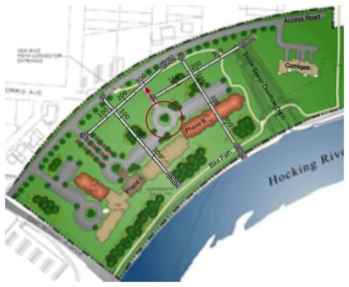

Categories:
eastside,
greenspace,
NCR,
OU,
parks,
retirement
1 comments:
You're doing a wonderful job with this site. It's not just well written; your arguments are logical and airtight.
I'd love to see everyone in Athens visit it!
(I do have my own blog, and I live in the Near Eastside neighborhood, but I don't generally focus on local issues.)
Thanks for starting this project. I look forward to seeing how it unfolds.
Warm regards,
Sungold
By: Sungold on May 28, 2008 at 4:42 PM
Post a Comment